


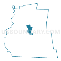
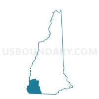
KEENE WARD 2, Cheshire County, New Hampshire
About
Outline

Summary
| Unique Area Identifier | 616205 |
| Name | KEENE WARD 2 |
| County | Cheshire County |
| State | New Hampshire |
| Area (square miles) | 11.33 |
| Land Area (square miles) | 11.21 |
| Water Area (square miles) | 0.12 |
| % of Land Area | 98.93 |
| % of Water Area | 1.07 |
| Latitude of the Internal Point | 42.95463440 |
| Longtitude of the Internal Point | -72.25046120 |
Maps
Graphs
Select a template below for downloading or customizing gragh for KEENE WARD 2, Cheshire County, New Hampshire


Neighbors
Neighoring Voting District (by Name) Neighboring Voting District on the Map
- KEENE WARD 1, Cheshire County, NH
- KEENE WARD 3, Cheshire County, NH
- TOWN OF GILSUM Voting District, Cheshire County, NH
- TOWN OF MARLBOROUGH Voting District, Cheshire County, NH
- TOWN OF ROXBURY Voting District, Cheshire County, NH
- TOWN OF SULLIVAN Voting District, Cheshire County, NH
Top 10 Neighboring County Subdivision (by Population) Neighboring County Subdivision on the Map
- Keene city, Cheshire County, NH (23,409)
- Marlborough town, Cheshire County, NH (2,063)
- Gilsum town, Cheshire County, NH (813)
- Sullivan town, Cheshire County, NH (677)
- Roxbury town, Cheshire County, NH (229)
Top 10 Neighboring Place (by Population) Neighboring Place on the Map
Top 10 Neighboring Elementary School District (by Population) Neighboring Elementary School District on the Map
Top 10 Neighboring Unified School District (by Population) Neighboring Unified School District on the Map
Top 10 Neighboring State Legislative District Lower Chamber (by Population) Neighboring State Legislative District Lower Chamber on the Map
- State House District 3, Cheshire County, NH (23,409)
- State House District 6, Cheshire County, NH (12,399)
- State House District 2, Cheshire County, NH (9,280)
- State House District 1, Cheshire County, NH (3,419)
Top 10 Neighboring State Legislative District Upper Chamber (by Population) Neighboring State Legislative District Upper Chamber on the Map
Top 10 Neighboring 111th Congressional District (by Population) Neighboring 111th Congressional District on the Map
Top 10 Neighboring Census Tract (by Population) Neighboring Census Tract on the Map
- Census Tract 9710, Cheshire County, NH (5,602)
- Census Tract 9704, Cheshire County, NH (5,425)
- Census Tract 9714.01, Cheshire County, NH (5,364)
- Census Tract 9711, Cheshire County, NH (5,161)
- Census Tract 9701, Cheshire County, NH (4,224)
- Census Tract 9708, Cheshire County, NH (4,208)
- Census Tract 9713, Cheshire County, NH (3,321)